The many railway bridges of Sandy Hill
Ken Clavette
In recent years, Sandy Hill has benefited from the addition of two new footbridges. The Corktown Footbridge/Passerelle Corktown opened in 2006, followed by the Adàwe Crossing/passerelle Adàwe in 2015. But in an earlier time, railways dominated the community’s bridges. In this 1958 aerial photo of the Hurdman area one sees quite a different set of bridges than today.
In the bottom of the photo (south), one can see the Canada Atlantic Railway bridge.The line was complete in 1883 from Coteau, Québec, to the Chaudière yards. This bridge is no more.
The next bridge north is the Ottawa & New York Railway, which arrived with a new line from Cornwall to Ottawa in 1898. Its yard and station were at the intersection of King Edward and Mann avenues. On February 16, 1957, New York Central Railroad that had taken over the Ottawa & New York Railway abandoned the line from Ottawa to Cornwall. That bridge is now a pedestrian and cycle crossing of the Rideau River, near the uOttawa Gee-Gees Field. [See below for more]
One can see the early stages of the Queensway in the photo. Rail lines were being removed. Construction of the new expressway got underway in 1957, when Queen Elizabeth detonated dynamite charges from the Hurdman Bridge.
The Hurdman Bridge just north of the Queensway, built in 1907, was not a railway bridge. It was a concrete arch bridge built by the City to replace the wood structure privately owned by the Hurdman family. The family’s first bridge had already collapsed once in 1902. In 1875, it had been only the third span to be built across the Rideau River.
The last railway bridge belonged to the Canadian Northern Ontario Railway. It opened a line from Hawkesbury to Ottawa, terminating at the foot of Henderson Avenue. It started service between Montreal and Ottawa on December 5, 1909. Taken over by the Canadian National Railway, it was the first major railway line to be abandoned in Ottawa. At low water levels one can still see the remains of the bridge’s foundation in the river. [Editor’s note: this is also visible in satellite images on Google Earth]
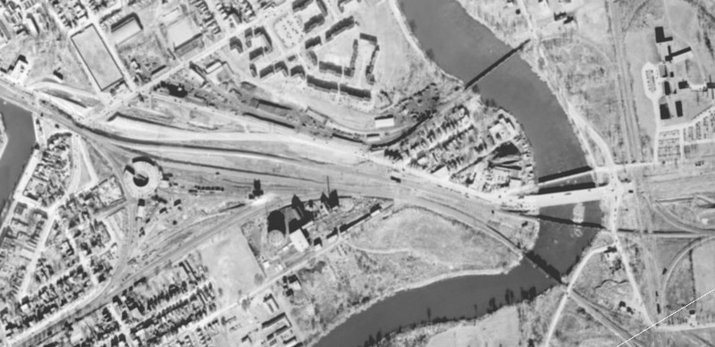
A 1958 aerial photograph showcasing the many rail bridges across the Rideau River. Can you recognize any off hand?
What’s in a curve? Discovering Ottawa’s CPR Rideau River Bridge
Barry Padolsky
Staying at home has its benefits. Beyond the public health contribution to slowing the spread of the COVID-19 contagion, staying at home grants us a rare temporal window for new personal discoveries.
If we interpret our neighbourhoods as “home,” (provided that we avoid close contact with our friends and strangers), we can explore our local communities in search of hidden landmarks: the extraordinary amidst the ordinary.
I have used my forced confinement in Ottawa’s Sandy Hill neighbourhood to see what I could find. As an architect, I can’t resist studying our urban habitat. It’s a compulsion. For the most part, our built environment is of limited distinction. Still, I am always in search of beauty.

Paterson George Collection, 1956.
On my morning walks along the Rideau River, I discovered the unexpected. The familiar arrow straight “Hurdman” footbridge across the Rideau River just south of the Queensway is curved!
Yes curved. And to my eye, it possesses an extraordinarily beautiful curve. I always assumed that it was straight. Yet when you squint along its axis, a most subtle curve is revealed, creating a visual liveliness that Ictinus and Callicrates, the architects of the Parthenon well understood in 438 BC.
Were the designers of this former railway bridge (constructed in 1898) sensitive artists as well as pragmatic engineers? Probably not. The bridge was just a part of a railway alignment that had to accommodate changes in train direction gradually. Especially at high speeds. Still the curve is beautiful.
Having discovered the “curve” I became curious about its geometry. It appears that the curve is an arc of a circle. I revisited my forgotten high school geometry lessons. Using the “intersecting chords theorem” I calculated that the radius of this arc was approximately 1.6 kilometres long, with its centre somewhere near the bowling alley on McArthur Avenue in Vanier. Unearthing this trivial fact was almost as satisfying as the experiencing the epiphany of the “curve.”
Instead of photographing the “curve” I took the time to capture it in a freehand ink drawing. This allowed me to savour the subtle magic of this utilitarian landmark as it emerged in my sketchbook. In these times of contagion we are urged to “flatten the curve.” Along with the Parthenon, this particular curved Ottawa landmark deserves to be savoured.
This article first appeared in The Ottawa Citizen on May 4, 2020.

Illustration Barry Padolsky